© Andrew Brown/2018/Malawi
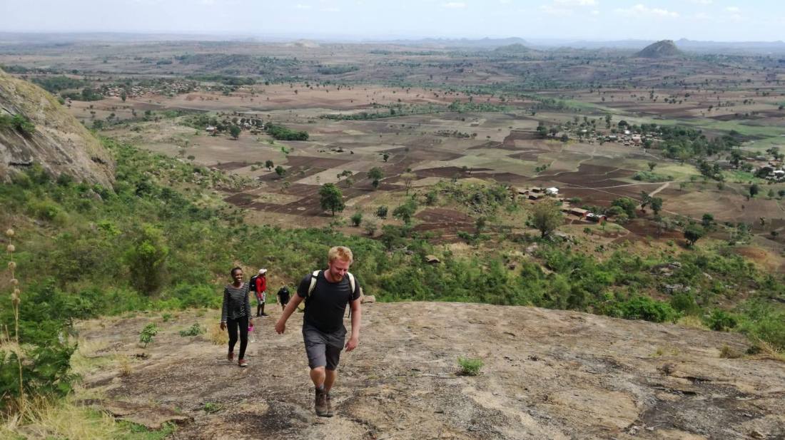
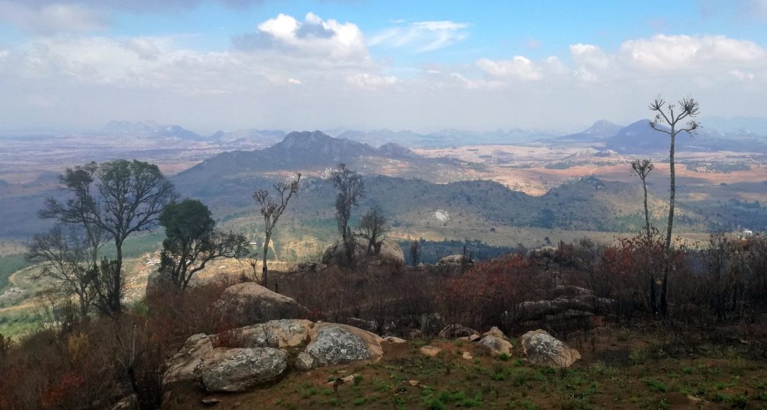
On a crisp, clear and unusually cloudless day during the rainy season, I made the peak of Dedza mountain with my friend Matthias and local guide James. The mountain rises to almost 2,200 metres above sea level. It towers over the nearby town of Dedza, which at 1,600 metres is already the highest town in Malawi. After a tough ascent to two radio towers at the near end of the mountain, we made our way along an indistinct path through scrubland and rocks, climbing a gently sloping plateau to the peak at the far end. Here, we were rewarded with a clear 360-degree view across central Malawi.
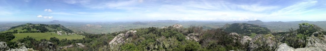
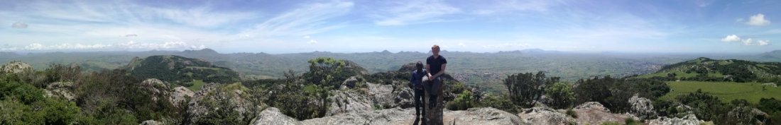
The highest point was marked with a concrete triangulation pillar. Looking east, we were high enough to see over the wall of hills that separates highland and lakeside Malawi. Beyond this, we could make out the faint outline of Lake Malawi, hazy in a lakeside heat that was a full 10 degrees hotter than where we stood on the mountain. We could trace the shoreline south to the town of Mangochi, and then more faintly back up the other side towards Mozambique.
Turning west, we could see mountains across the border in Mozambique, which wraps the much smaller Malawi in its embrace on both sides. The border was much closer here, just a few kilometres outside Dedza, leading to a thriving cross border trade including in Mozambique beer, several crates of which would later fill the boot of Matthias’s car. To the north and south the M1 highway (actually just an ordinary two-lane road with relatively few potholes) snaked away to Lilongwe and Blantyre.

© Andrew Brown/2017/Malawi
It was a stunning view, and a reminder that there is much more to the country than the famous Lake Malawi. The former colonial name of Malawi was Nyasaland, literally Lake Land, and much of the country’s tourism is focused around the third largest in Africa. But although less known than its lake and safari parks, Malawi also has some great mountain hikes. The ultimate challenge is the 3002 metre Mount Mulanje in the south, an area supposedly haunted by ghosts and vampires. Unfortunately, Mulanje is a three-day hike, and with two small children I haven’t had time to tackle it. But there are many other mountains in Malawi, and almost all are climbable with a bit of local assistance.
As well as the mountain, Dedza is a great place to escape the heat of lowland Malawi. In the hot season, temperatures at the lake soar to over 35 degrees and mosquitos swarm the shores, feasting on visitors’ blood. In Dedza, however, the mountain climate keeps temperatures to the mid-20s during the day and it’s properly cold at night. It’s the one place in Malawi that I’ve found an electric heater in my bedroom, instead of a fan.
When visiting Dedza, I stay at the Pottery Lodge, a pleasant combination of clay kilns, shop and restaurant, and a handful of basic but clean rooms. With frequent power cuts, one of the pleasures of Malawi is going outside at night and watching the stars. On a clear night, I could clearly see the white band of the Milky Way and the pitch black of Dedza mountain, outlined like a cut out against the sprinkling of stars behind.
© Andrew Brown/2017/Malawi
Shapes of animals
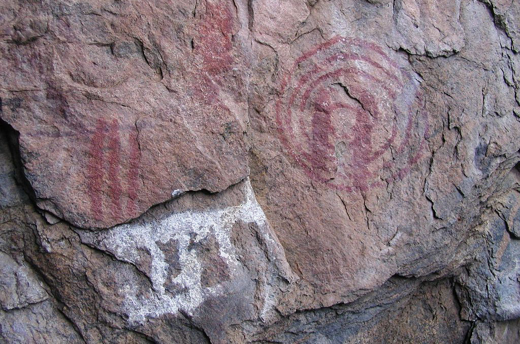
Other than the mountain, Dedza’s main attraction is its prehistoric cave paintings. There are more paintings here than in any other part of East Africa. They are located in a series of caves around a distinctive hill called Chongoni, topped with a ridge of seven jagged spikes. It looks a bit like an upside-down carving knife. I had the phone number of another guide, Lemton, from a previous visit so we arranged to meet him at a school near the foot of the hill.
It was actually Lemton’s job to mind the caves. “I am a civil servant in the Department of Antiquities. I live in the village and my office is over there,” he explained, pointing at a small hut with an information board outside. “I take school children to see the paintings. I tell them to just look and not write their names on the rock. There are 27 known cave painting sites in Malawi, but these are the best preserved.”
Together, we hiked up the hill to the first cave, passing a young boy sat on the rocks and minding a herd of goats. As we walked, Lemton explained that there were two distinct styles of cave painting in the area. “There are white and red paintings,” he said. “The white paintings were done 2,000 years ago by the Chewa people. These are the ancestors of my people, who still live here. The red paintings were done 10,000 years ago by pygmies [the Batwa]. When the Chewa people came to this area, they fought with the pygmies, who fled to Congo.”
© Wikipedia (I need to dig out my own photos!)
I soon realised that Lemton’s explanations were a mixture of fact, guesswork and blatant invention. The leaflet I picked up from the lodge dated the recent paintings to 500 years ago, and the oldest ones to 2,000 years, a very different timescale to the one given by Lemton.
The first cave was in a spectacular location on the side of the mountain. The view took in farmland in the valley below, with Dedza mountain beyond. We could see tiny people moving through the fields below, roofs of village huts and the school where we started, and the boy we had passed on the way up. I wondered if the cave painters had had a similar appreciation of the view, or whether it was a just practical choice for shelter.
“People lived in this cave,” Lemton said. “The rain doesn’t come in, which is why the paintings are well preserved. They could also see their enemies coming.” He pointed at a tight tunnel beneath a rock overhang. “There are still hyenas living further back in the cave,” he added. They’re sleeping now, but they come out at night.”
The paintings in this cave were white and relatively recent. They clearly showed animals, including a lion, chameleon, rooster and duck. Lemton pointed out the various animals and showed us where someone had drawn an outline around the paintings, during the colonial period, to make the shapes clearer.
© Andrew Brown/2017/Malawi
The Big Dance
Interestingly, the caves still have a ritual purpose. There’s a religion in the area called Gulu Wamkulu (The Big Dance). It’s very secretive and most Malawians I’ve asked about it just laugh and change the subject. From those who are willing to discuss it, I’ve heard wildly different explanations. Some say it is a form of animism with ancient tribal roots. Others that it is a secret society based around villages where the inhabitants believe themselves to be ghosts. Some even say that it is an off-shoot of Christianity, based on the worship of the golden calf that Moses’s followers made while he was on Mount Sinai, according to Biblical legend. Possibly, it contains elements of all three.
The most visible element of Gulu Wamkulu is people dressed up as animals or spirits at funerals and other ceremonial occasions. They wear costumes made of straw with frightening painted masks, and dance in a jerky, otherworldly fashion, enhancing their non-human appearance.
Lemton subscribed to the view of Gulu Wamkulu as an ancient belief. “You can see that the animals shown in the cave paintings are the same as the costumes that the dancers wear today,” he said. “The villagers come up here for their rituals, including initiation ceremonies when boys become men.”
We walked back down the hill to the best preserved of the pygmy caves, in a narrow ravine between two large rocks at the foot of the hill. Here, the paintings were stained a deep red and, unlike the Chewa paintings, were mostly geometric patterns. Lemton identified these as ladders and moons, although there was no clear evidence for this. They looked more abstract to me. There were also small handprints, which certainly fitted with the pygmy theory.
The one animal painting we saw in the red cave was a single, very tall giraffe. It looked for all the world like it was eating the leaves of a slender tree that grew out of a crack at the side of the rock face. Of the course the tree itself was much more recent than the painting, but I wondered if another tree had grown in the same place in ancient times. It was strange to feel that a Batwa artist was speaking to us across the millennia.

© Andrew Brown/2018/Malawi
Nkhoma mountain
Dedza mountain is just out of sight of the capital Lilongwe, where I live, but there are three others that are visible from town. Nkhoma Mountain, with its distinctive triangular peak. Ngala or Big Mouth Mountain, which has a giant cave shaped like a smiling mouth on one flat face. And one between Nkhoma and Dedza, that for lack of a better name I’ve taken to calling ‘In Between Mountain’.
After climbing Dedza mountain, we decided to tackle Nkhoma. One of the fun things about travelling with Matthias is that he’s a qualified drone pilot. For the Nkhoma hike, he brought his personal drone packed into a surprisingly small backpack. We were joined by Matthias’s girlfriend Sheila and another friend Nora.
Together, we set off early on Saturday morning for Nkhoma village. This is the headquarters of the Church of Central African Presbyterian and it feels for all the world like a rural English town, with a stone church, brick houses and careful tended gardens. It’s like a small corner of colonial Malawi, where the British never left. And in fact that’s almost exactly what it is, peopled by a mixture of Malawians and British missionaries who stayed behind after independence.
The Nkhoma hike is well described by fellow blogger Jenny. The route is fairly straightforward, so we went without a guide. The challenge, however, is finding the start of the path. We got lost wandering through the village until a local woman offered to show us the way. Taking off her shoes, she raced up the hillside while we struggled to keep up.

© Andrew Brown/2018/Malawi
The path wound past two lakes with views of round roofed farmers’ huts that merged chameleon-like into the environment, resembling large boulders. It then veered steeply up the side of the mountain. Once we had got to a decent height, Matthias launched his drone and sent it out across the valley, until it dwindled to a distant speck. The drone seemed further away than it actually was, because it was so small to start with.
When the drone was almost lost to sight on the far side of the valley, Matthias turned it round and brought it back in. It quickly turned back from a speck into an identifiable drone, then came in fast and low above us, shooting dramatic video as it went overhead (which I will attempt to edit and upload to YouTube).
After the drone flight it was a short climb to the plateau, where we found a basic lodge used by missionaries, who come up for prayer and meditation. It also has other uses. “A friend of mine hired the lodge for his birthday,” Matthias said. “A bunch of us came up here and had a big party. Sometimes I come up on my own and camp out. I like lying on the edge of the cliff at night and watching the fires on the plain below.”
From the lodge, the final ascent of the triangular peak climbs a narrow gully full of rocks and short trees. We eventually emerged onto a series of flat slabs of rock at the summit. We were very lucky with the weather. Dark storm clouds rolled dramatically across the sky, creating patches of shade and bright sunlight on the earth below. Yet the promised rain never quite reached us. After enjoying the dramatic scenery and picking out distant landmarks of Lilongwe, we returned the way we came and headed back home, stopping briefly at the Mozambique border to pick up another crate or two of beer.
© Andrew Brown/2018/Malawi
Big Mouth Mountain
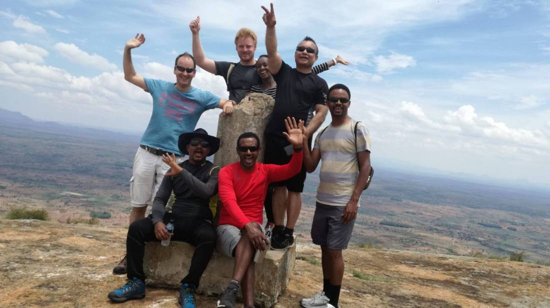
Also worthy of note is Ngala Mountain, which is a similar distance south of Lilongwe but on the other side of the road. Locals call it Big Mouth Mountain, because of a curved cave on the sheer rock face, which looks like a smiling mouth. Its friendly face and rounded shape make it look like an easy hike but this proved deceptive. Unlike Nkoma and Dedza, there is no clear path up Ngala and much of the climb involves scrambling over bare rock. Local children, dogs and goats scamper up and down effortlessly but for us it was a tough climb.
The view from the summit was worth the effort. I was climbing with a group of Ethiopians, Tedla, Mihereteab and Anteneh, and we had a picnic of injera (flatbread) and wat (spicy stew) at the top. Tedla even rolled out a blanket and portable stereo, creating a festive atmosphere.
On the way back down, we passed a makeshift Rastafarian temple on a rocky outcrop across the valley from our path. We could see the worshipers playing drums and dancing. Mihereteab shouted out “King of Kings!” to them in greeting and they called back. My knowledge of Rastafarianism was limited to Bob Marley and marijuana, so Mihereteab filled me in.
“Rastafari is actually based on the worship of Ethiopian Emperor Haile Selassie,” Mihereteab explained. “He visited Jamaica in the 1960s. People believed he was the messiah and would bring Jamaicans back to Africa. It’s recently started becoming popular here as well.”

© Andrew Brown/2018/Malawi
Mount Mulanje
Although I never managed to climb Mount Mulanje, I did manage to go there with work. One of our programmes involves desk deliveries for primary schools and scholarships for girls at secondary school. I went with US donor Lawrence O’Donnell to deliver desks to Ngangala Primary School, which sits on a plateau beneath Mulanje Mountain.
Mulange is actually a massif rather than a mountain. It’s a vast plateau of rock that erupts from the otherwise flat surrounding plain. Driving from Blantyre, at first I didn’t see the mountain, because I was looking below the clouds. Then I spotted it rising above the clouds, a dark blue silhouette against the pale blue sky. It bears more than a passing resemblance to Table Mountain and often has a similar ‘tablecloth’ of clouds rolling along its ridge. At 3,002m, however, Mulanje is almost three times as high as Table Mountain (1,085m).
The mountain wraps around Ngangala Primary School on three sides with dramatic views of cliffs and cascading waterfalls. It’s in the middle of a tea estate and we had a slow journey along earth roads, made worse by recent rains. On the way, we overtook two lorries loaded with desks. At the school, we filmed the desks arriving and being unloaded and carried into the classrooms by some of the older boys at the school, including 16-year-old Johan Kadjau.
After the desks were all in the classrooms, we interviewed an exhilarated Johan. He told us that in the past, students used to run away from school because they did not want to spend the day sitting on the stony ground. “But now the desks have come I’m very happy because I’ll start writing at a desk,” he said. “All the learners here, we’re very happy because things like desks have been missing from this school. Today is an unforgettable day.”

© Andrew Brown/2018/Malawi

One thought on “Higher ground: climbing the mountains of Malawi”